FFS
From BurnZero
Where are the best places to flyer/cold call for recruitment?
2020 XR recruitment map
NSW Data
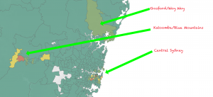
The main areas in NSW which have high density of XR members are:
- Central Sydney (see below) in the East
- Katoomba in the West
- Gosford/Woy Woy in the North
- Support is limited in the south.
Central Sydney
The most dense areas include (from highest to lowest):
- CBD (501 sign ups)
- Marrickville (187 sign ups)
- Newtown (144 sign ups)
- Bondi (142 sign ups)
- Randwick (100 sign ups)
- Surry Hills (89 sign ups)
- Glebe (94 sign ups)
- Leichhardt & Lilyfield
- Dulwich hill
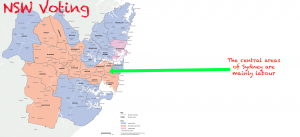
2019 Federal Voting Map[1]
The central areas of Sydney mainly vote labour, however the surrounding suburbs are conservative.
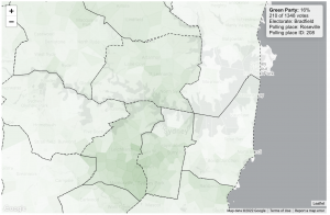
2019 Regional elections Green Votes[2]
NSW is run by by a Liberal/National coalition. To the right is a breakdown of the area which voted green the most.
- Annandale (33%)
- Petersham (28%)
- Darlington (29%)
- Stanmore (31%)
- Summer Hill (26%)
- St Leonards (21%)
- Cammeray Central (19%)
Cultural Diversity[3]
There are a wide range of cultures in Sydney. Key demographics include:
- Chinese (10.8%)
- Irish (9.2%)
- Scottish (6.8%)
- Italian (4.5%)
- Indian (4.3%)
- Lebanese (3.5%)
- German (2.7%)
- Greek (2.6%)
- Vietnamese (2.3%)
- Filipino (2.3%)
- Indigenous (1.5%)
- Korean (1.4%)
- Maltese (1.3%)
Conclusion
Target areas:
- Marrickville
- Newtown
- Darlington
- Bondi
- Randwick
- Surry Hills
- Glebe (94 sign ups)
- Leichhardt & Lilyfield
- Dulwich hill
- Annandale
- Petersham
- Stanmore
- Summer Hill
- St Leonards
- Cammeray Central
References
- ↑ https://www.aec.gov.au/Elections/federal_elections/2019/files/maps/2019-aec-A3-NSW-maps.pdf
- ↑ https://www.theguardian.com/australia-news/datablog/ng-interactive/2019/jul/03/mapping-every-vote-extremely-detailed-maps-on-the-2019-election
- ↑ https://smallmultiples.com.au/projects/mapping-immigrants-birth-places/


